

Categories
Capturing opportunities for OpenStreetMap data to better support Anticipatory Action
There are a vast array of opportunities for open geospatial data, like OpenStreetMap (OSM) to support anticipatory action. This blog captures key insights and examples of how the German Red Cross, along with different partners of the Anticipation Hub - 510 (an initiative of the Netherlands Red Cross), Humanitarian OpenStreetMap Team (HOT) and the Heidelberg Institute for Geoinformation Technology at Heidelberg University, are working towards enhanced application of OSM in research and practice to better support Anticipatory Action.
The role of OSM data for developing Early Action Protocols
The German Red Cross strives to capture opportunities to utilise open source geospatial data in their methodological approach to implementing anticipatory action on the ground with National Societies. For example, in the recent development for an Early Action Protocol (EAP) on flooding in the Philippines, the German Red Cross conducted a Missing Maps mapping campaign to improve geospatial data for Butuan City. One of the early actions to be implemented in urban areas in case of flooding in the Philippines is the temporary relocation of small businesses. Because the time between the trigger and the actual flood event happening is relatively short, a preselection of those small businesses needs to be done in advance. Remote volunteers in Germany helped create a basemap of the city, which local volunteers from the Philippines Red Cross then used in a mobile data collection survey to gather information on vulnerable businesses (read more here). This information can now help to shape an effective response if the flood trigger is reached. This example demonstrates the power of OSM to generate the exposure data needed to develop detailed plans that can be quickly activated to trigger anticipatory action. It also shows the power of OSM to mobilize global support from volunteers and build their understanding of geospatial data and its applications in practice.
Filling the data gap & ensuring local data is maintained
The Humanitarian OpenStreetMap Team (HOT) is an international team dedicated to humanitarian action and community development through open mapping. HOT works together with partners to provide map data that can revolutionize disaster management, reduce risks, and contribute to achieving the Sustainable Development Goals. The completeness and maintenance of local map data is a key element in anticipatory action, as it can support local actors in their decision-making. HOT can help to expand the application of OSM for anticipatory action by supporting NGOs, governments and other actors in the Anticipation Hub to identify data gaps, and to create and effectively use OSM data in their work. This involves connecting organizations with existing OSM communities who are leading on mapping where they live.
For example, HOT has been contributing to the development of PhilAWARE, a custom hazard monitoring and early warning system to improve disaster management and decision making in the Philippines. It consolidates hazard information and alerts from various sources for the agencies’ disaster preparedness and response. This will also ease the sharing of information among the country’s disaster managers from the national, regional, and local levels, with warning and alerts disseminated to the impacted communities. This example demonstrates the huge potential for OSM data to fill the data gap, enhance data maintenance and build local capacity for data readiness that can subsequently facilitate early action.

Enhancing impact assessments for Impact Based Forecasting
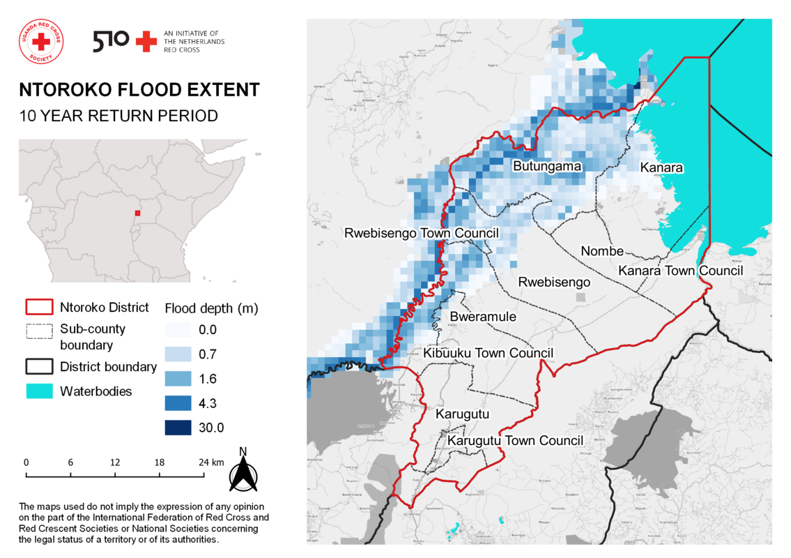
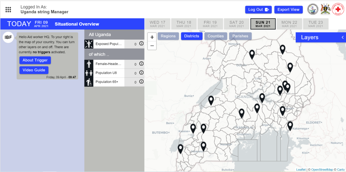
510’s purpose is to improve speed, quality and cost-effectiveness of humanitarian aid by using and creating data and digital products. The Impact Based Forecasting Dashboard is one of those products. Impact Based Forecasting predicts the impact of impending disasters on vulnerable people living in areas that are prone to these disasters. The dashboard integrates risk and impact assessment and makes it visual to support operational decision making. 510, for example, can use OpenStreetMap (OSM) data to help determine risk and impact on human settlements and infrastructure. This was the case when 510 worked together with The Uganda Red Cross Society (URCS) during their flood analysis. In this analysis we overlaid flood extent data with OSM data in order to measure the severity of the flood and identify which human settlements and infrastructure would be most impacted. Similar analysis can also be applied for other disasters such as typhoons and droughts and can be used to help National Societies in deciding to adopt certain measures in their Early Action Protocols.
In order for National Societies to run these data and digital products on their own it is crucial to increase data literacy. The Anticipation Hub offers an opportunity to bring together the key partners working on open data, to enhance collaboration and strengthen our shared capacity to build data literacy. “We can improve data literacy by creating more experts through our partnership with the Anticipation Hub … we have a unique group of partners here that can contribute to that.” says Stefania Giodini (Team lead at 510).
Understanding data
The Heidelberg Institute for Geoinformation Technology at Heidelberg University (HeiGIT) improves knowledge and technology transfer from fundamental research in geoinformatics to practical applications. OSM is a key ingredient for the humanitarian sector to apply anticipatory action in practice. While the organizations commonly engage with questions around data quality, they need tools that will support systematic data quality evaluation using an explicit set of requirements. HeiGIT has built years of expertise in the assessment of user generated big spatial data quality (e.g. completeness) and its fitness-for-purpose, and develops tools that facilitate humanitarian actions.
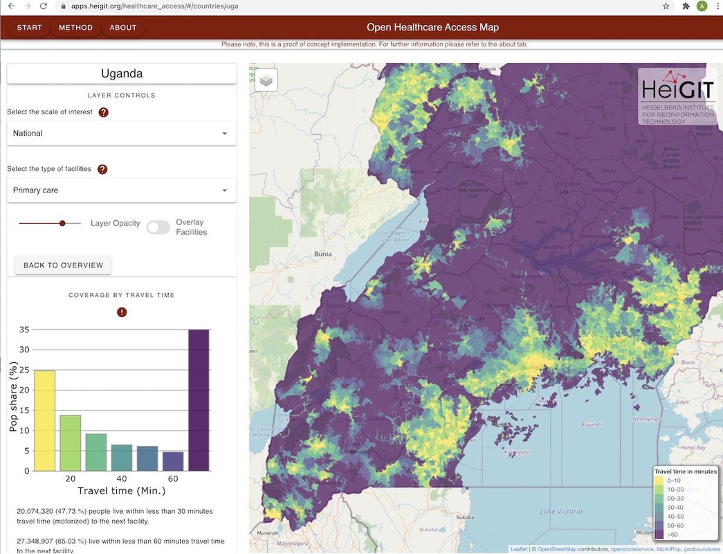
For example, the ohsome framework offers a wide range of tools to evaluate spatio-temporal OSM data quality for different use cases, allowing us to tackle questions such as: How suitable is the settlement layer from OSM for creating a Malawi country overview map? In which countries is the OSM road network of insufficient quality for creating logistics and transportation maps? The answers to these questions will inform critical data preparedness activities in countries with humanitarian need. In addition, HeiGIT supports humanitarian and anticipatory action with its openrouteservice and especially openrouteservice for disaster management (ors4DM). One specific application for anticipatory action based on openrouteservice is the new web application from HeiGIT called Open Healthcare Access Map that provide insights into healthcare supply on different spatial scales for many countries worldwide. The tool can be used before the emergency to identify the most vulnerable populations and during the emergency to capture dynamic up-to-date information from OSM data on healthcare facilities and damaged areas. This can help humanitarian actors to make decisions about safe routes that avoid flooded roads or damaged buildings.
We hope this blog provided some additional insights into the application of OSM for anticipatory action now and in the future. This is an exciting area of development and we look forward to continued interaction and knowledge exchange on this topic going forward. Please get in touch with us if you have any questions.
This blog was prepared by:
- Sander Houston, Communication Officer at 510, initiative of The Netherlands Red Cross
- Katharina Lorenz, Manager Geoinformatics at the German Red Cross
- Carly Redhead, Head of Partnerships, Humanitarian OpenStreetMap Team
- Sarah Lohr, Research Associate, HeiGIT