Categories
Using global forecasts to support humanitarian decision making during major tropical cyclones
Tropical Cyclones (or Hurricanes as they are called in the Atlantic) are the most powerful storms on earth. They cause destruction from strong winds and coastal flooding where they make landfall and bring heavy rainfall leading to further flooding as the storm tracks inland. To respond effectively, humanitarians need to know how bad flooding will be, when it will occur, where the impacts will be greatest and hence where their resources will be needed most.
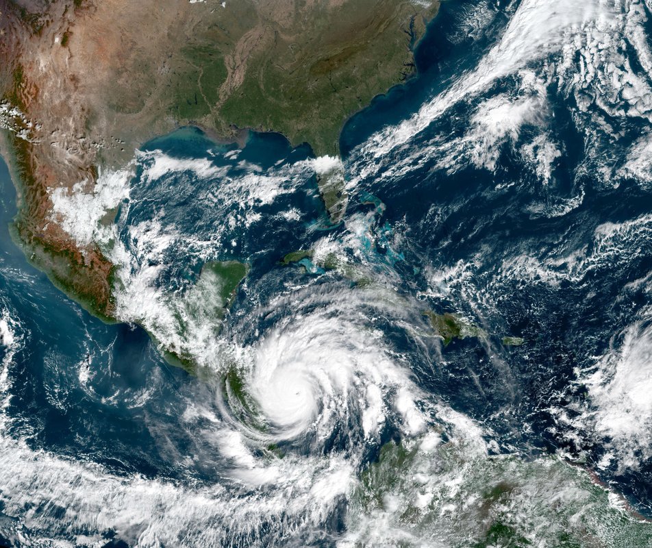
In many locations where tropical cyclones occur, local forecasting capacity is limited. In some places Early Action Protocols (EAPs) based on global flood forecasts support anticipatory action in advance of events. Having the potential to produce impact-based flood bulletins for (almost) anywhere in the world, and being able to share them quickly and easily across humanitarian organisations during major events, is highly valuable for decision makers, even if there is no EAP in place.
Tropical Cyclones Idai and Kenneth
The use of global forecasts to support humanitarian response during tropical cyclones Idai and Kenneth in Mozambique was first trialled in 2019. A multi-disciplinary team (from University of Reading, University of Bristol, ECMWF and Fathom) combined flood forecasts from the European Commission’s Global Flood Awareness System (GloFAS, a Copernicus EMS service) with global flood inundation models and exposure datasets to produce flood bulletins explaining the flood hazard and potential impacts on population and critical infrastructure (the details are explained in this research paper and this blog post). The response from users was positive, having access to forecasts and an assessment of potential impacts improved decision making:
“This is the first time we have been able to use science so early in both planning for and responding to the devastating impact of cyclones.“
Prof. Charlotte Watts, Chief scientific advisor, FCDO
“The bulletins were very helpful. They gave us an overview of which rivers were at greatest risk of flooding, and this helped inform where we gave the greatest attention to.”
Gemma Connell, Head of Regional UN OCHA in Southern and Eastern Africa
A new pilot project
Building on the success of the bulletins produced during Idai and Kenneth, the UK Foreign, Commonwealth and Development Office (FCDO) funded a pilot project to further explore the potential of global forecasts. Bulletins were produced for two events, Hurricane Iota in Central America in November 2020 and Tropical Cyclone Eloise in Mozambique in January 2021. The FCDO played a valuable role in the production of the bulletin, acting as an intermediary and enabling us to modify the information provided in the bulletin during events to meet decision-makers’ needs. In addition to the team from Idai and Kenneth, HR Wallingford joined to provide coastal surge modelling expertise.
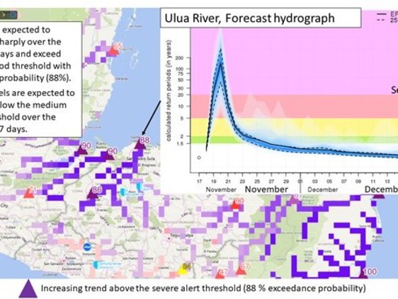
Example forecast hydrograph for the Ulua River in Honduras during Hurricane Iota (source: GloFAS)
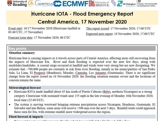
Bulletin for Hurricane IOTA

Example forecast hydrograph for the Ulua River in Honduras during Hurricane Iota (source: GloFAS)
Bulletin for Hurricane IOTA
Hurricane Iota
Hurricane Iota affected Nicaragua, Honduras, Guatemala, and parts of other bordering countries. It made landfall only 24km south of where Hurricane Eta had come ashore just 2 weeks earlier. River levels were already high, the humanitarian community was already in response mode and some communities had already been displaced. Iota caused a storm surge of up to 8m with rainfall of up to 510mm. Eta and Iota affected around 5 million people with mud/land/rockslides and flooding reported across Central America causing damage to houses, roads and infrastructure.
The first flood bulletin for Hurricane Iota was produced the day before landfall. Ongoing research into the predictability of flooding from tropical cyclones shows that the lead time could have been extended. One of the key challenges for Iota was providing information for the mountainous catchments and isolated communities that were of concern to humanitarian responders. The global models used are developed using large-scale datasets. This means they are not recommended for use in small catchments where local variations in geology and topography affect river flows, or where flooding occurs from small streams and surface water rather than the river. However, by using our knowledge of the large-scale situation and local gauged data (where it was available) we were able to interpolate between known points and provide some information on flood extent. We also focussed on impacts to the access roads further down the river that, if flooded, could isolate these communities. The bulletins were successfully used by humanitarian agencies and the military to inform actions on the ground prior to the floods occurring.
Tropical Cyclone Eloise
Tropical Cyclone Eloise made landfall near Beira. According to the National Institute for Disaster Risk Management and Reduction (INGD), 441,686 people were affected with over 56,000 houses severely damaged or destroyed. The region was still recovering from Cyclone Idai in 2019. When Eloise made landfall in January 2021, many people were already displaced following the impact of tropical storm Chalane on 30th December 2020.
We had identified the potential of an impactful cyclone as early as 14th January (9 days before landfall) and started discussion with FCDO. The first full flood bulletin was produced the day before landfall. Humanitarian partners on the ground, such as the Red Cross Red Crescent Movement, received the bulletins and were able to utilise them for the purpose of early, informed decision-making next to other international and national forecasting products. The Mozambique Red Cross, as an example, was able to use the bulletins to put their Forecast-based Financing (FbF) team on alert for a possible Flood Early Action Protocol (EAP) activation, as they indicated a high likelihood of flooding in the Limpopo River basin due to heavy rainfall associated with Tropical Cyclone Eloise.
A key question from humanitarians during Eloise was how severe the event was compared to Idai. By overlaying the satellite observations of inundated area with population and OpenStreetMap data we were able to show that Eloise was a much smaller event, enabling humanitarians to plan accordingly. The bulletin’s flood extent maps and identification of critical infrastructure at risk of flooding were used by the Mozambique Red Cross and partners in conjunction with the EAP’s composite vulnerability index to inform operational planning of the once the flood trigger of the Limpopo EAP was reached.
We were in direct contact with the scientific team behind the bulletins and were able to be informed by them, as well as feedback information on national-level hydrological forecasts we received from our focal point at the National Directorate of Water Resources Management (DNGRH) from our end. It was good to see how the bulletins were evolving and started to reflect additional information coming from the team in the field.
The bulletins put the Forecast-based Financing (FbF) mechanism in Mozambique on alert, signalling early on with significant lead time that precipitation related to Tropical Cyclone Eloise would lead to flooding in the Limpopo River basin, long before national hydrological forecasts reflected this. The information allowed the Mozambique Red Cross and Governmental partners to focus multi-hazard anticipatory actions two-fold: on the cyclone’s impact close to Beira, as well as associated flooding in southern Mozambique.
How could global forecasting systems better support humanitarians?
The flood bulletins have shown that in the absence of local forecast models, or to increase the lead time for anticipatory action, global forecasts can provide useful information to support humanitarian decision making. FCDO reported that humanitarian colleagues are appreciative and excited by the expertise and insight this pilot enabled during Tropical Cyclone flooding events.
"In our view the project has served an immediate need for a conduit of rapid advice regarding the fluvial and surge flooding hazards considered; but has also helped make incremental but substantive advances in the rigour and suitability of the underlying approach, process and content of concerning the rapid communication of the relevant science for Early Warning benefit.”
Tim Sumner and Katherine Mardsen, FCDO
However, our experience showed that the successful use of global forecasts requires an understanding of the strengths and limitations of the global models used and the underlying data sets. For example the bulletins for Iota and Eloise benefitted from the team’s knowledge of emerging research on the predictability of flooding from tropical cyclones and the impact of lead time on flood thresholds in GloFAS, which was communicated through the expert assessment of flood hazard in the bulletin itself and through daily discussions with FCDO. Questions remain around how to expand this pool of expertise and incorporate this knowledge directly within the forecast interface.
Looking to the future, global forecasting systems could provide even more valuable information to support humanitarian decision making if we work together to:
- Build on existing partnerships to better understand user needs during major events (for example those built while developing EAPs). Engage in conversations about how to balance these against the scientific and practical limitations of the forecasting approach during “peace time” rather than in the heat of an event.
- Improve the bulletin design, content and language to be more accessible. Incorporate emerging knowledge about forecast skill from ongoing research directly within the model platforms and bulletin production process.
- Support new scientific research to address outstanding questions. Research such as, how to assess the skill of global models in ungauged catchments, and how to improve synergies between global models and the local context by incorporating observed river levels, local forecasts, dam operations alongside satellite imagery and observed impacts.
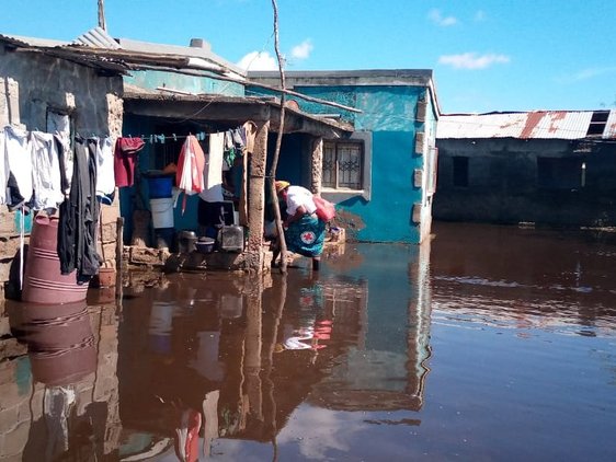
Flooding in the Lower Limpopo Basin after Tropical Cyclone “Eloïse” in February 2021 © Mozambique Red Cross
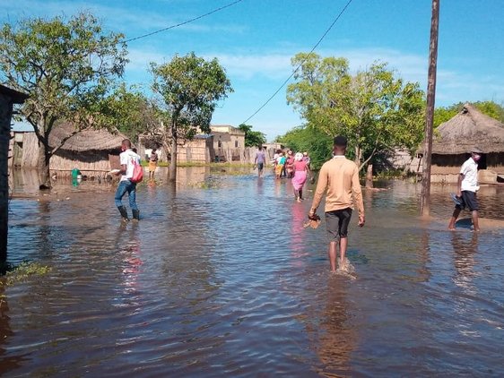
Flooding in the Lower Limpopo Basin after Tropical Cyclone “Eloïse” in February 2021 © Mozambique Red Cross

Flooding in the Lower Limpopo Basin after Tropical Cyclone “Eloïse” in February 2021 © Mozambique Red Cross
Flooding in the Lower Limpopo Basin after Tropical Cyclone “Eloïse” in February 2021 © Mozambique Red Cross
This blog was written by Dr Linda Speight, University of Reading, with input from German Red Cross, Mozambique Red Cross and UK Foreign, Commonwealth and Development Office.
For more information about the Flood Early Warning pilot project please contact Dr Linda Speight l.j.speight@reading.ac.uk or Dr Liz Stephens elisabeth.stephens@reading.ac.uk.
