
Categories
Compound Risk Analysis: Climate & Conflict in Sudan - Hot spot mapping to inform anticipatory action and OpenStreetMap mapping
Conflict, fragility, and violence are major drivers of humanitarian crises, causing up to 80% of all humanitarian needs. Violent conflict was termed ‘development in reverse’, caused by its severe negative impacts on social and physical infrastructures, leading to development regression. However, conflict-affected states are often neglected by Disaster Risk Reduction (DRR) efforts even though the effects of conflict exacerbate vulnerabilities of people living in the areas.
Example of how conflict can exacerbate vulnerabilities
The image gallery below showcases an example of how conflict can exacerbate vulnerabilities. In Sudan conflict has caused a high number of refugees and IDPs to settle within flood areas. People are potentially exposed to floods while at the same time their capacities to mitigate or cope are decreased, increasing their vulnerability, and creating a complex disaster risk setting.
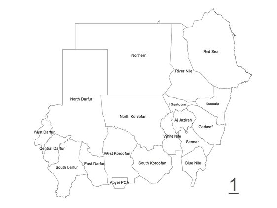
1. Sudan
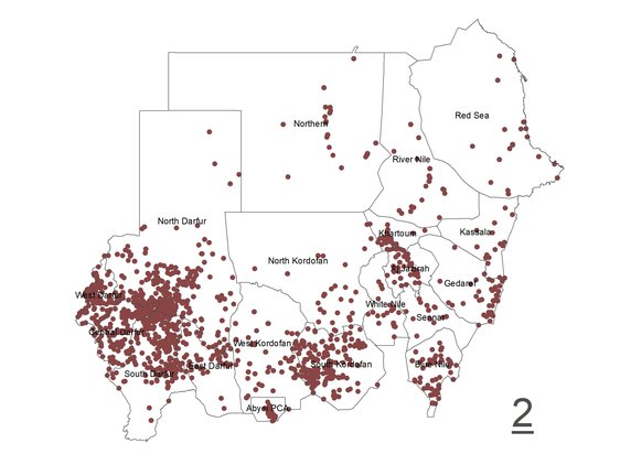
2. Conflict incidents between 2000 – 2021
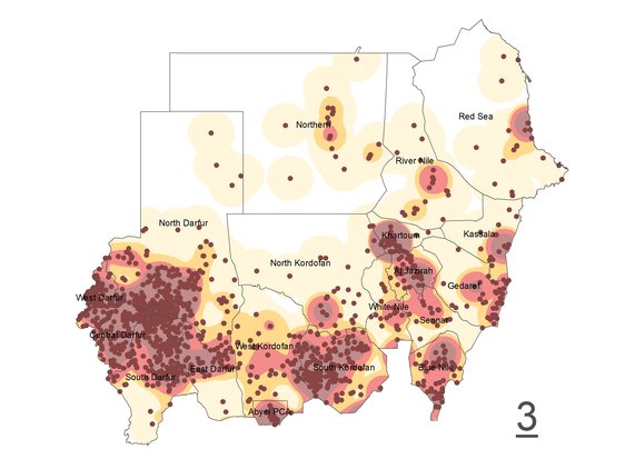
3. Density analysis of incident points to identify conflict hot spots
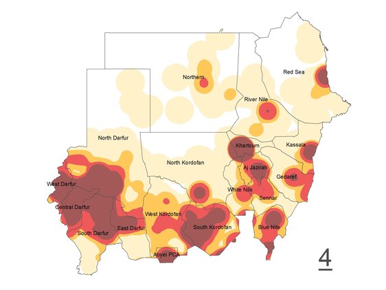
4. Conflict hot spots in Sudan between 2000 – 2021
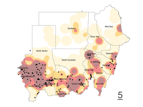
5. Locations of IDP and refugee camps/settlements
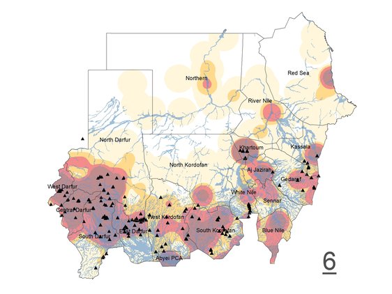
6. Flood areas
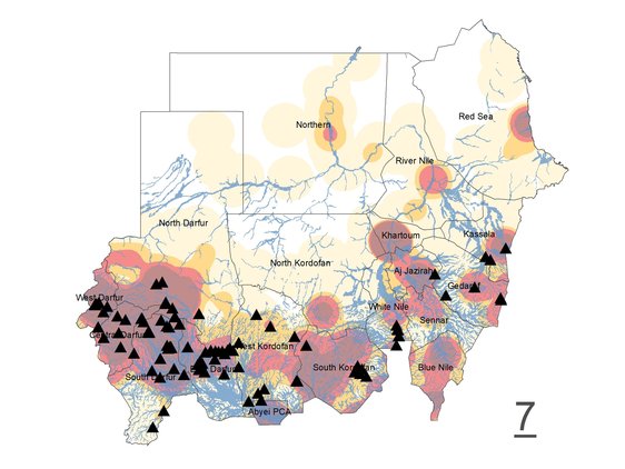
7. IDP and refugee camps/settlements located in flood areas

1. Sudan
2. Conflict incidents between 2000 – 2021
3. Density analysis of incident points to identify conflict hot spots
4. Conflict hot spots in Sudan between 2000 – 2021
5. Locations of IDP and refugee camps/settlements
6. Flood areas
7. IDP and refugee camps/settlements located in flood areas
To reach those most affected, innovative humanitarian approaches like Forecast-based Action (FbA) needs to be expanded to conflict settings. FbA is a form of anticipatory action, an innovative form of assistance, provided before a disaster hits to mitigate its impacts early ahead. The expansion of anticipatory action to new settings and areas like conflict-affected regions, requires extensive information about the areas and the people living there. It is crucial to know who lives where and how to plan early actions to save lives and livelihoods and reach those most in need.
Anticipatory action is currently piloting in a number of countries (e.g. Bangladesh, Mongolia where data availability has been sufficient for the planning of early actions. Meanwhile, countries with extensive data gaps tend to be ruled out as projects’ location due to the lack of essential information needed for the planning of early actions. Data scarcity is especially an issue in countries with long term conflicts and protracted crises. The lack of governmental functions or active hindering of data collection (e.g. mapping areas) has created data gaps, hindering the planning of humanitarian assistance in some regions most in need. Sudan is one of the countries this accounts for. Long-term conflicts and protracted crisis have exacerbated vulnerabilities and created complex disaster risk settings throughout the country. Sudan appears widely unmapped in OpenStreetMap and geospatial data is overall scarce.
To work into this gap, this study explored ways to identify and prioritize high-risk and unmapped areas in Sudan. The analysis focuses on areas in Sudan which historically have been affected by floods, drought and high vulnerabilities exacerbated through a history of being affected by conflict. The aim is to use the identified and prioritized unmapped, high-risk areas to guide volunteer OSM mapping efforts to map the gaps in these areas. The created mapping material will render invisible lives visible on the maps of our world and help enable the expansion of anticipatory action to new settings and areas which so far had been left out.

Sudan Priority Areas - Country Context & Local Knowledge
A discussion with experts with local & country knowledge of the conducted mapping study and proposed priority areas for OSM mapping in Sudan gave following preliminary insights into the current country context of identified priority areas in Sudan:
1. Nyala
The Nyala area has a high number of IDPs and refugees. Many have settled along the riverbanks in the east and are exposed to flooding. Multiple floods have impacted IDPs and refugees in the Nyala area in the past years.
2. Geneina
Small scale, armed tribal conflicts are occurring in West Darfur, causing new IDPs to move to the area around Geneina. These conflicts are considered unpredictable in location and time of occurrence and can start and end suddenly.
3. North-Khartoum
The area of North-Khartoum is highly exposed to flooding, affecting a high number of people (possibly also IDPs and refugees but no definite numbers known).
4. White Nile River Banks
Multiple Refugee Camps are located near or partly in flood prone areas along the White Nile riverbanks north of the border to South Sudan.
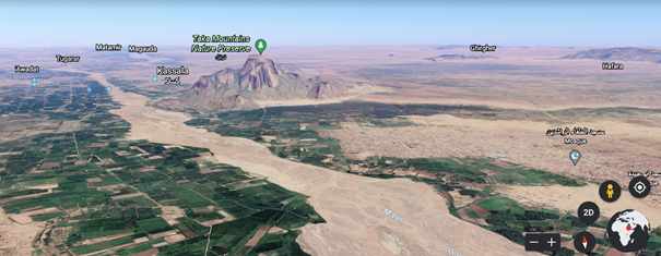
5. Kassala
The area of Kassala is expecting an influx of refugees fleeing the conflict in Ethiopia. Kassala is located at the Mareb/Gash river and prone to flooding. The Wadsharefy refugee camp is located near Kassala, partly within the flood areas and expected to expand in the near future.
Moving forward
Major challenges of expanding anticipatory action to new countries and settings like conflict settings include extensive data scarcity as well as ethical considerations regarding conflict context. The methodology developed in this study of conducting a weighted overlay analysis to identify and prioritize geographic high-risk areas can be expanded and adapted to different settings and in new context. It can be leveraged as tool to prioritize areas, scale up OSM mapping and close crucial risk data gaps. Using this geospatial analysis in the identification and prioritization of high-risk areas can further play a key role for impact-based forecasting in anticipatory action. To make full use of this methodology in expanding anticipatory action to new settings it will have to be combined with detailed historical disaster impact analysis, expert inputs of local and country knowledge and further activities done to set up anticipatory action systems.
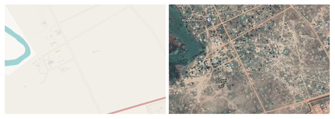
The first mapping tasks of priority areas in Sudan went online in the OSM tasking manager in October 2021 and are currently in the process of being mapped. Starting the mapping process was made possible through the support of MSF by setting up the tasks and accessing satellite imagery of the area, and the MissingMaps chapter of the Netherlands Red Cross.
The mapping tasks focus on two areas in East-Sudan:
Author:
Cornelia Scholz (2021), Red Cross Red Crescent Climate Centre (RCCC); University of Copenhagen – Copenhagen Center for Disaster Research (COPE)
For more information please contact:
- Cornelia Scholz: ‘LinkedIn’
- Catalina Jaime: jaime@climatecentre.org