Bridging the gap: establishing the basis of subseasonal flood forecasting in East Africa
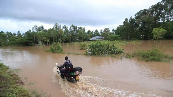
In 2018 Kenya experienced one of its wettest seasons on record. Exceptionally high rainfall in distinct periods throughout the “long rains” season resulted in extensive flooding, loss of around 200 lives, impacts on livelihoods, displacement of people, disruption to essential services and damage to infrastructure. Overall, 800,000 people are estimated to have been affected.
Was there sufficient warning? A post-event analysis suggests not. No signal of a wet season was apparent in seasonal forecasts. Following this, the next indication of heavy rainfall was the Kenya Meteorological Department’s heavy rainfall advisories before each in-season rainfall period. Whilst these advisories are generally accurate, they only provide a few days heads-up, limiting the potential for preparedness. Indeed, evidence from key informants suggests that the level of flood preparedness in 2018 was low compared to previous seasons.
Earlier warning may have facilitated better preparedness - but is there always a trade-off between lead time and uncertainty. Whilst seasonal forecasts scan a long horizon, forecast signals are quite broad (think seasonal averages) and uncertainty is generally high. Alternatively, forecasts for the next few days can be much more specific with high confidence – but their lead time may be too short to make sufficient preparedness.
Subseasonal forecasts have the potential to bridge this gap. They provide an outlook of average conditions over the next few weeks: more precise than seasonal forecasts, more lead time than weather forecasts. But are they skilful? This is one of the questions we set out to answer in the ForPAc project (Toward Forecast-based Preparedness Action, www.forpac.org), a UK-Kenya consortium which has explored and developed potential for forecast-based preparedness in Kenya. We report our findings in a new paper – which we dissect below.
Why is subseasonal forecasting possible?
Weather and climate phenomena span a continuum of timescales, from a single rain cloud through to large-scale ocean-atmosphere phenomena such as El Niño Southern Oscillation (ENSO). The state of ENSO is predictable many months ahead and it affects regional climate around the world: it is this predictability and influence that underlies seasonal forecasting.
Somewhere between ENSO and a single rain cloud exists something called the Madden-Julian Oscillation (MJO). This is a large-scale system of coupled convection in the tropics, moving eastward around the globe, intensifying and dissipating as it does so. Like ENSO, the MJO is predictable; several weeks (not several months) ahead. And like ENSO, MJO impacts regional rainfall around the world. In the same way that ENSO underlies seasonal forecasting, MJO opens the possibility for subseasonal forecasting – predicting fluctuations in average conditions over the next few weeks.
Evaluating MJO teleconnections and subseasonal forecast skill
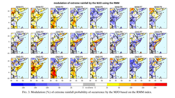
A link between MJO and East Africa is well known (generally, when the MJO is active in the Indian Ocean, East Africa tends to be wetter). In our paper we extend this understanding by demonstrating a strong relationship between the MJO and extreme rainfall.
We then evaluate leading subseasonal forecast models from ECMWF and the UK Met Office to see how well they represent the MJO-East Africa teleconnection. This teleconnection is crucial for models to get right: a good MJO prediction is not enough to ensure good subseasonal rainfall predictions. Thankfully we find that the models do a pretty good job of recreating the observed MJO teleconnection. We find some deviations from reality: a target for future model improvements.
Now with models which predict the MJO several weeks ahead AND that reproduce its teleconnection to East Africa, we expect skilful subseasonal forecasts. That is exactly what we find: we evaluate a dataset of forecasts covering two decades, showing that in many parts of East Africa forecasts for heavy rainfall weeks (upper quintile) show reliable and sharp probabilities out to two and even three weeks ahead. That means that the models often issue high probabilities and when they do, those probabilities are a good indication of the change in risk.
Drivers of riverine flooding: the Nzoia basin of Western Kenya.
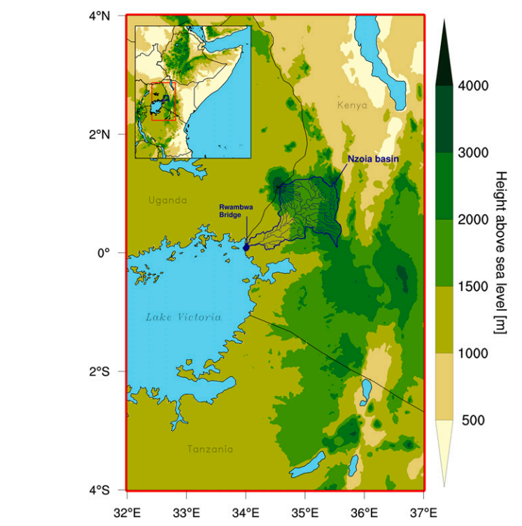
That isn’t the end of the story: whilst a heavy rainfall week is a key driver of some kinds of flooding, for riverine flooding, hydrology can complicate the picture. So, we wanted to know: how meaningful is our definition of heavy rainfall weeks for riverine flooding? To answer this question for a flood-prone basin in the region we used a ~70-year record of discharge for the Nzoia river of Western Kenya. This particular river has the only operational riverine flood forecast in Kenya, providing a three-day ahead outlook. The potential for extending the lead time with subseasonal forecasts is a question of keen interest from stakeholders.
Analysis of the Nzoia data showed us that our definition of heavy rainfall week event to be a clear trigger of Nzoia historical flooding events. But in addition to this the analysis made clear that representing pre-existing basin saturation conditions is essential to accurately capturing the hydrological response to rainfall input.
So, to make a decent subseasonal forecast of river flooding you need a skilful forecast of rainfall input, coupled to a representation of basin hydrology. This exactly describes the setup of the GloFAS system, which uses the ECMWF subseasonal forecast along with a hydrological model and representation of hydrological initial conditions to provide flood forecasts over the next few weeks and beyond. We took a look at GloFAS over the Nzoia, finding that some (but not all) flooding events were anticipated with several weeks lead time. This supports the use in early warning (although we deeper evaluation is ongoing to understand the reason why some key recent flooding events are missed).
Impact-based subseasonal forecasts?
So, are subseasonal forecasts skilful over East Africa? Yes: the MJO provides predictability and leading forecast models from ECMWF and the UK Met Office are able both to predict the evolution of the MJO and represent its teleconnection. Heavy rainfall weeks can be anticipated with reliable probabilities. Hydrological models driven by skilful subseasonal rainfall forecasts such as GloFAS have the potential to provide long-lead reliable warning of river flooding. Science clearly supports the development of subseasonal forecast products in East Africa. In fact, the region stands out as a global hotspot of subseasonal forecast skill.
Putting this into action, initiatives such as the S2S project are providing operational subseasonal forecasts through pilot projects: in East Africa these are currently being trialled on a limited basis through the ForPAc and Africa SWIFT projects. Sustaining this beyond this initiative is crucial and opening up this access to this forecast data from global producing centres is essential. In doing so regional forecast providers will be able to work together with stakeholders to provide tailored impact forecasts: not just for flooding, but for agriculture, health and beyond. New initiatives such as the H2020 project, DOWN2EARTH are working to this agenda in the region, translating climate information into decision-relevant information on water scarcity.
This development of impact-based subseasonal forecasting will help to reduce risks, save lives and livelihoods and adapt to an uncertain future. Extreme seasons like the 2018 long rains in Kenya will happen again - but with subseasonal forecasts, the outcomes could be different next time.
Written by David MacLeod, Senior Research Associate, School of Geographical Sciences, University of Bristol. Please get in touch with the author if you have any questions about the research.
Read what others think about the importance of this research for anticipatory action in practice:
As we implement anticipatory action, we are seeing the need for seamless early warning information on what the weather will do. Such research that is making advances toward seamless forecasts and advocating for Impact based forecasting (IBF) will go a long way in supporting the sustainability of anticipatory action while at the same time supporting the most vulnerable communities.
The Madden-Julian Oscillation (MJO) is known to influence rainfall around the world, and research such as this provides confidence in applying this knowledge to provide longer lead times for forecast-based action. I hope this inspires further research beyond the Nzoia river basin in Kenya.